Private Pilot Licence - Helicopter
Demo: PPL/H
Real exam questions to try for free — no registration needed.
How do spread and relative humidity change with increasing temperature?
Show solution
As temperature increases, the spread (difference between temperature and dew point) increases because temperature rises faster than dew point. Relative humidity decreases since warmer air can hold more moisture, but the actual water vapor stays the same.
The "spread" is defined as...
Show solution
The 'spread' is the difference between actual temperature and dew point. It indicates how close the air is to saturation. The other options describe ratios, other differences, or the maximum water vapor, which are incorrect.
The saturated adiabatic lapse rate is...
Show solution
The saturated adiabatic lapse rate is lower than the dry adiabatic lapse rate because condensation releases heat, slowing the cooling. The other options are incorrect: it is never equal to, proportional to, or higher than the dry adiabatic lapse rate.
The dry adiabatic lapse rate has a value of...
Show solution
The correct answer is 1.0°C/100 m, as dry air cools by 1°C per 100 m ascent. 0.65°C/100 m and 0.6°C/100 m are for moist air. 2°C/1000 ft is an approximation, but not exact for the dry adiabatic lapse rate.
Clouds are basically distinguished by what types?
Show solution
The correct answer is 'Cumulus and stratiform clouds' because clouds are basically classified as cumulus (heap) and stratus (layer) types. 'Thunderstorm and shower clouds' and 'stratiform and ice clouds' are special or incomplete categories. 'Layered and lifted clouds' is not a standard classification.
What condition may prevent the formation of "radiation fog"?
Show solution
Overcast cloud cover prevents radiation fog because it blocks heat loss from the ground at night. The ground doesn't cool enough for fog to form. The other conditions actually favor fog by allowing more cooling or moisture.
How is an air mass described when moving to Central Europe via the Russian continent during winter?
Show solution
Continental polar air is correct because it comes from the cold, dry Russian landmass in winter. Maritime air masses come from the sea, tropical air from warmer regions. Only continental polar air matches cold, dry winter air from Russia.
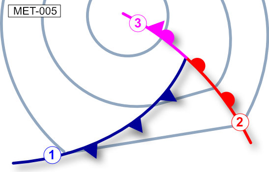
The symbol labeled (2) as shown in the picture is a / an... See figure (MET-005)
Show solution
The symbol with a line and semicircles represents a warm front. The others are: front aloft (not standard), occlusion (semicircles and triangles), and cold front (line with triangles). Only the warm front uses only semicircles.
What visual flight conditions can be expected after the passage of a cold front?
Show solution
After a cold front, visibility usually improves. Cumulus clouds with rain or snow showers form. The other options describe conditions typical before or during the front, such as poor visibility, stratus clouds, or prolonged precipitation.
What pressure pattern can be observed during the passage of a polar front low?
Show solution
Correct: Falling pressure in front of the warm front, constant pressure within the warm sector, rising pressure behind the cold front. Before the warm front, pressure drops; in the warm sector, it stays steady; behind the cold front, it rises. The other options do not match the typical pattern of a polar front low.
What change of wind direction can be expected during the passage of a polar front low in Central Europe?
Show solution
Correct: Veering wind during passage of the warm front, veering wind during passage of the cold front. In Central Europe, wind turns clockwise (veers) with both fronts. The other options are wrong because they mention backing or a mix, which is not meteorologically correct.
What weather phenomena have to be expected around an upper-level trough?
Show solution
Around an upper-level trough, showers and thunderstorms (Cb) are likely, as cold air aloft causes instability. The other options describe calm or stable weather, which is not typical for upper-level troughs.
What weather conditions in Central Europe are typically found in high pressure areas during summer?
Show solution
In high pressure areas during summer, large isobar spacing means weak winds and local wind systems often form. The other options are incorrect because they mention strong winds or small isobar spacing, which are not typical for high pressure areas.
What wind conditions can be expected in areas showing large distances between isobars?
Show solution
Large distances between isobars mean a weak pressure gradient, so winds are usually light, variable, and local wind systems can form. Strong prevailing winds or rapid changes occur with closely spaced isobars, not wide ones.
What weather conditions can be expected during "Foehn" on the windward side of a mountain range?
Show solution
Correct: Layered clouds, mountains obscured, poor visibility, moderate or heavy rain. On the windward side, moist air rises, cools, and condenses, causing thick clouds and rain. The other options describe the leeward side or are incorrect for the windward side.
Which of the following conditions are most favourable for ice accretion?
Show solution
The highest risk of icing occurs between 0°C and -12°C with supercooled water droplets in clouds. The other options are incorrect because they are either too cold, too warm, or lack supercooled droplets, which are essential for ice accretion.
What temperatures are most dangerous with respect to airframe icing?
Show solution
The range from 0°C to -12°C is most dangerous because supercooled water droplets freeze most easily on aircraft surfaces. The other ranges are less critical, as less icing-prone water is present at those temperatures.
What danger is most immenent when an aircraft is hit by lightning?
Show solution
The main danger from lightning is surface overheating and damage to exposed aircraft parts, as the current passes through the skin. Disturbed radio, equipment explosions, or rapid depressurization are rare or less likely.
What has to be considered when taking off in a ground inversion?
Show solution
During climb in a ground inversion, a sudden decrease in speed and climb performance can occur due to changing air density. The other answers are incorrect: there is no sudden increase, no typical icing, and climbing at minimum speed is not recommended.
Information about pressure patterns and frontal situation can be found in which chart?
Show solution
The surface weather chart displays pressure patterns and frontal positions at ground level. Hypsometric, wind, and SWC charts do not provide this ground-level information.
What chart shows areas of precipitation?
Show solution
A radar picture shows areas of precipitation because radar detects reflections from raindrops or snow. Satellite pictures show clouds, not direct precipitation. GAFOR is for flight weather, not precipitation. Wind charts only show wind direction and speed.
Weather and operational information about the destination aerodrome can be obtained during the flight by...
Show solution
ATIS broadcasts current weather and operational information for a specific airport. VOLMET gives weather for several airports, PIREP are pilot reports, SIGMET warns of hazardous weather. Only ATIS provides targeted info for the destination aerodrome.
What can be expected for the prevailling wind with isobars on a surface weather chart showing large distances?
Show solution
Widely spaced isobars mean low pressure gradients, resulting in weak prevailing winds. Closely spaced isobars indicate strong pressure gradients and strong winds. So, only the answer with low pressure gradients and low wind is correct.
Mountain side updrafts can be intensified by ...
Show solution
Solar irradiation on the windward side intensifies updrafts because it heats the air, causing it to rise more strongly. Solar irradiation on the lee side, nighttime thermal radiation, or warming of upper layers do not have this effect.
Ground-based weather radar is used to detect and display:
Show solution
Ground-based weather radar displays precipitation, as it detects reflections from raindrops or snow. It cannot directly show clouds, pressure patterns, or temperatures, since these do not reflect radar waves sufficiently.