Private Pilot Licence - Aeroplane
Demo: PPL/A
Real exam questions to try for free — no registration needed.
What is the purpose of engine oil in piston engine?
Show solution
Engine oil cools and lubricates the engine and removes fine abrasion. It does not directly increase performance, is not just for the propeller shaft, and does not serve for noise reduction.
Where does the inclination reach its lowest value?
Show solution
The inclination is lowest at the magnetic equator because the Earth's magnetic field lines are parallel to the surface there. At the magnetic and geographic poles, inclination is highest. At the geographic equator, it is not necessarily zero.
Electronic devices on board of an aeroplane have influence on the...
Show solution
Electronic devices create magnetic fields that can disturb the direct reading compass. Artificial horizon, turn coordinator, and airspeed indicator do not rely on magnetism and are not affected.
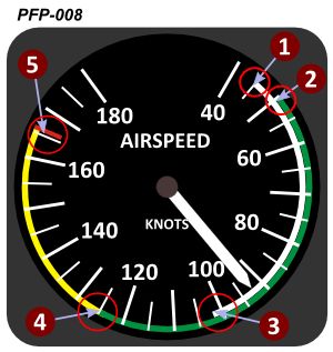
The red marking at the end of the yellow arc (5) indicates which airspeed? See figure (PFP-008)
Show solution
The red marking indicates VNE (Never-exceed speed). This is the maximum speed the aircraft must not exceed to avoid structural damage. The other options refer to different speeds not marked by the red line.
The rotational axis of the Earth runs through the...
Show solution
The Earth's rotational axis runs through the geographic North and South Poles, as these are the true rotation points. The magnetic poles are offset and move over time, so they are not the axis points.
Which statement is correct with regard to the polar axis of the Earth?
Show solution
Correct: The polar axis of the Earth crosses the geographic South Pole and the geographic North Pole and is perpendicular to the plane of the equator. The Earth's axis passes through the geographic, not magnetic, poles and is perpendicular to the equator. Other answers confuse poles or give wrong angles.
Which statement about a rhumb line is correct?
Show solution
Correct: A rhumb line cuts each meridian at the same angle. This is its definition. The other options are wrong: a rhumb line is not a great circle, it is not the shortest path, and its center is not always the Earth's center.
The shortest distance between two points on Earth is represented by a part of...
Show solution
The shortest distance between two points on Earth is always along a great circle. Small circles, rhumb lines, and parallels of latitude are longer or follow different paths, so they are not the shortest route.
The circumference of the Earth at the equator is approximately...
Show solution
The correct answer is '21,600 NM.' because 1 degree of latitude equals 60 NM and the equator is 360 degrees (360 × 60 = 21,600 NM). '40,000 NM.' and '10,800 km.' are too large or too small, '12,800 km.' is also too low.
Where are the two polar circles?
Show solution
The polar circles are each 23.5° from the North and South Poles. This is correct due to Earth's axial tilt. The other options are incorrect because they use wrong latitudes or reference points.
What distance corresponds to one degree difference in latitude along any degree of longitude?
Show solution
One degree of latitude equals 60 NM because 1 degree along a meridian always measures about 60 nautical miles. 1 NM, 60 km, and 30 NM are incorrect as they do not match the true distance of one degree of latitude.
Point A on the Earth's surface lies exactly on the parallel of latitude of 47°50'27''N. Which point is exactly 240 NM north of A?
Show solution
1 degree of latitude equals 60 NM. 240 NM equals 4°. Adding 4° to 47°50'27''N gives 51°50'27''N. The other options are either too far north, too far south, or too close to the starting point.
What is the great circle distance between two points A and B on the equator when the difference between the two associated meridians is exactly one degree of longitude?
Show solution
The correct answer is 60 NM because one degree of longitude at the equator equals exactly 60 nautical miles. The other options are too large and do not match the definition of a nautical mile, which is 1/60 of a degree at the equator.
What is the difference in time when the sun moves 20° of longitude?
Show solution
The Earth rotates 360° in 24 hours. For 20°, it takes 1 hour 20 minutes. The other answers are incorrect as they are either too short or too long. 1:20 h is correct because 20° × 4 minutes = 80 minutes = 1:20 h.
What is the difference in time when the sun moves 10° of longitude?
Show solution
The correct answer is 0:40 h because the Earth rotates 360° in 24 hours, so 1° equals 4 minutes. Therefore, 10° equals 40 minutes. The other answers are incorrect as they are either too much, too little, or far too little time.
With Central European Summer Time (CEST) given as UTC+2, what UTC time corresponds to 1600 CEST?
Show solution
1600 CEST is two hours ahead of UTC. So, 1600 CEST equals 1400 UTC. The other answers are incorrect because they do not account for the two-hour time difference.
With Central European Time (CET) given as UTC+1, what UTC time corresponds to 1700 CET?
Show solution
The correct answer is '1600 UTC.' CET is one hour ahead of UTC, so you subtract one hour. The other answers are incorrect because they subtract too much, too little, or do not convert at all.
The term 'civil twilight' is defined as...
Show solution
Civil twilight is the period before sunrise or after sunset when the sun's center is 6 degrees or less below the true horizon. The other answers are incorrect because they mention 12 degrees or the apparent horizon, which is not the correct definition.
The angle between the true course and the true heading is called...
Show solution
The angle between true course (TC) and true heading (TH) is called WCA (Wind Correction Angle), as it corrects for wind drift. Deviation and variation are magnetic errors, and inclination refers to magnetic field tilt.
The term 'True Course' (TC) is defined as...
Show solution
The true course (TC) is the angle between true north and the course line. Magnetic north relates to magnetic course, and directions to the poles are not course definitions.
The term 'isogonal' or 'isogonic line' is defined as a line on an aeronautical chart, connecting all points with the same value of...
Show solution
Correct: a line connecting all points with the same variation. Variation is the angle between true and magnetic north. The other options are incorrect: deviation, inclination, and heading refer to different navigation concepts.
Which are the official basic units for horizontal distances used in aeronautical navigation and their abbreviations?
Show solution
In aeronautical navigation, nautical miles (NM) and kilometers (km) are used for horizontal distances because they are internationally standardized. Land miles, yards, meters, feet, and inches are not standard for this purpose.
1000 ft equal...
Show solution
1,000 feet equal about 300 meters, since 1 foot is about 0.3048 meters. 30 meters and 3,000 meters are too little or too much, and 30 kilometers is far too much. Only 300 meters is correct.
How are rhumb lines and great circles depicted on a direct Mercator chart?
Show solution
On a Mercator chart, rhumb lines are shown as straight lines because they keep a constant bearing. Great circles appear curved, as they represent the shortest path. The other options are incorrect as they mix up these representations.
An aircraft is flying with an indicated airspeed (IAS) of 150 kt at 8000 ft MSL. According to the rule of thumb, the true airspeed (TAS) equals...
Show solution
True airspeed (TAS) increases with altitude. Rule of thumb: add 2% per 1000 ft to IAS. At 8000 ft, that's 16%, so 150 kt + 16% ≈ 174 kt. The other answers are too low, too high, or just the IAS.