Private Pilot Licence - Aeroplane
Demo: PPL/A
Real exam questions to try for free — no registration needed.
Given: True course from A to B: 250°. Ground distance: 210 NM. TAS: 130 kt. Headwind component: 15 kt. Estimated time of departure (ETD): 0915 UTC. The estimated time of arrival (ETA) is...
Show solution
The correct answer is 1105 UTC. Headwind reduces groundspeed to 115 kt (130-15). 210 NM / 115 kt = 1.83 h ≈ 1 h 50 min. 0915 UTC + 1 h 50 min = 1105 UTC. The other options result from incorrect speed or time calculations.
Given: True course from A to B: 352°. Ground distance: 100 NM. GS: 107 kt. Estimated time of departure (ETD): 0933 UTC. The estimated time of arrival (ETA) is...
Show solution
The correct answer is 1029 UTC. 100 NM at 107 kt GS gives a flight time of about 56 minutes. 0933 UTC + 56 minutes = 1029 UTC. The other times are either too early or too late and do not match the calculated flight time.
An aircraft travels 110 NM within 01:25. The ground speed (GS) equals...
Show solution
Ground speed is calculated by dividing 110 NM by 1.42 hours (1:25 h), which gives about 78 kt. 86 kt is too high, and 160 km/h and 120 km/h are not in knots, so they are incorrect.
An aircraft is flying with a true airspeed (TAS) of 180 kt and a headwind component of 25 kt for 2 hours and 25 minutes. The distance flown equals...
Show solution
The correct answer is 375 NM. TAS 180 kt minus 25 kt headwind gives 155 kt groundspeed. 2 hours 25 minutes is 2.42 hours. 155 kt × 2.42 h = 375 NM. The other answers are incorrect as they are either too high or too low and do not match the calculation.
An aircraft is flying at FL 75 with an outside air temperature (OAT) of -9°C. The QNH altitude is 6500 ft. The true altitude equals is:
Show solution
True altitude is lower than QNH altitude because the temperature is colder than ISA. At -9°C at FL75, true altitude is about 6250 ft. The other answers are too high or equal to QNH altitude, which is not correct in colder air.
An aircraft is flying at a pressure altitude of 7000 feet with an outside air temperature (OAT) of +21°C. The QNH altitude is 6500 ft. The true altitude equals...
Show solution
True altitude equals pressure altitude when temperature is standard. At +21°C at 7000 ft, it's warmer than standard, so true altitude is higher than QNH altitude. The correct answer is 7,000 ft. The other options are too low.
Given: True course: 255°. TAS: 100 kt. Wind: 200°/10 kt. The true heading equals...
Show solution
The correct answer is 250°. The wind comes from the left front, so the heading must be corrected slightly to the right. 250° is the correct wind correction. 245° is too far left, 265° and 275° are too far right.
An aircraft is following a true course (TC) of 220° at a constant TAS of 220 kt. The wind vector is 270°/50 kt. The ground speed (GS) equals...
Show solution
The ground speed is 185 kt because the wind from 270° (almost from behind) partially adds to the TAS of 220 kt. 255 kt is too high, 170 kt and 135 kt are too low, as the tailwind effect is not that strong.
An aircraft is following a true course (TC) of 040° at a constant true airspeed (TAS) of 180 kt. The wind vector is 350°/30 kt. The groundspeed (GS) equals...
Show solution
The groundspeed is 159 kt because the wind comes from ahead and slightly from the left, reducing the groundspeed. The other values are too high as they do not account enough for the headwind effect.
An aircraft is following a true course (TC) of 040° at a constant true airspeed (TAS) of 180 kt. The wind vector is 350°/30 kt. The wind correction angle (WCA) equals...
Show solution
The wind correction angle is -7°. This means the aircraft must steer 7° left to maintain course. The other values are either too large or in the wrong direction (too much or to the right).
Given: True course: 270°. TAS: 100 kt. Wind: 090°/25 kt. Distance: 100 NM. The ground speed (GS) equals...
Show solution
The correct answer is 125 kt because a tailwind (wind from 090° on a 270° course) adds the wind speed to the TAS. 100 kt + 25 kt = 125 kt. The other answers are incorrect as they do not properly account for the wind or are mathematically wrong.
Given: True course: 270°. TAS: 100 kt. Wind: 090°/25 kt. Distance: 100 NM. The flight time equals...
Show solution
The correct answer is 48 min. The strong headwind (wind from 090° on a 270° course) significantly reduces groundspeed. The other answers are incorrect because they ignore the wind effect or result in flight times that are too high or too low.
Given: QTE: 203° VAR: 10° E The QDR equals...
Show solution
QTE is the true bearing from the station. To get QDR (magnetic), subtract easterly variation: 203° - 10° = 193°. The other answers are incorrect because they either add the variation or use wrong calculations.
The pilot receives a QDR of 225° from the VDF ground station. Where is the aircraft located in relation to the ground station?
Show solution
A QDR of 225° means the aircraft is on the 225° bearing from the station, which is southwest. The other directions (northwest, northeast, southeast) correspond to different bearings and are incorrect.
Which equipment is needed on board of an aircraft to receive signals from a non-directional beacon (NDB)?
Show solution
The Automatic Direction Finder (ADF) is the only equipment designed to receive NDB signals. The other devices (CDI, SSR, HSI) cannot receive or display NDB signals.
A pilot wants to approach an NDB on QDM 090°. The aircraft flies for about 5 minutes with a magnetic heading (MH) of 095° and the RBI indication of 355°. After 6 minutes the RBI indicates 358°. Which statement is correct?
Show solution
The crosswind component increased; the pilot has to increase the MH. The RBI shows the wind is pushing the aircraft more, so the pilot must correct further to the right. The other answers are incorrect because they misinterpret the wind change or the required heading correction.
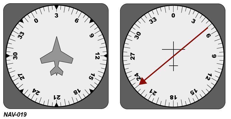
The pilot wants to proceed directly to the beacon. The wind is calm. The pilot should follow a QDM of: See figure (NAV-019)
Show solution
The correct answer is 260. With calm wind, the pilot must fly the QDM that points directly to the NDB. The other values (200, 230, 080) point in different directions and do not lead directly to the beacon.
The range of NDBs transmitting in the medium frequency range is greatest...
Show solution
The range of NDBs in the medium frequency band is greatest at night because the ionosphere reflects radio waves better then. During the day, at midday, and before midday, solar radiation disturbs the ionosphere, reducing range.
VOR radials are defined based on the principle of...
Show solution
VOR radials are defined by phase comparison of two signals. The other options are incorrect because amplitude, frequency, or pulse comparison are not used for direction determination in VOR systems.
Full deflection of the course deviation indicator (CDI) means that the aircraft is located at least...
Show solution
Full deflection of the CDI means the aircraft is at least 10° beside the selected course. This is because full CDI deflection represents a 10° deviation. The other options are incorrect as 2° is too small, and NM values do not directly relate to CDI deflection.
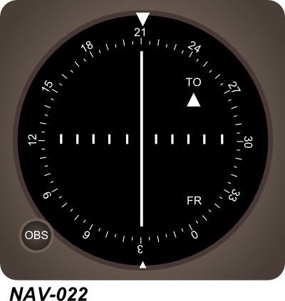
Where is the aircraft located in relation to the VOR? See annex (NAV-022)
Show solution
The aircraft is northeast of the VOR because the indicator and heading show the plane is approaching the VOR from the northeast. The other directions are incorrect as they do not match the displayed position and heading.
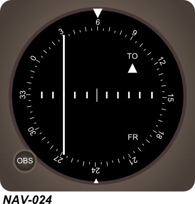
The aircraft is on radial: See annex (NAV-024)
Show solution
The aircraft is on radial 234 because radials are measured from the station outward. The other options (246, 060, 066) represent different directions that do not match the aircraft's indicated position.
The range of a VOR is affected by...
Show solution
The range of a VOR depends on the altitude of the transmitter and receiver, as VORs operate on line-of-sight. Daylight interference, ground wave multipath, and reflected sky waves do not significantly affect VOR range.
The distance measuring equipment (DME) determines the distance based on the principle of...
Show solution
DME measures distance by timing how long a radio signal takes to travel to the ground station and back. Phase comparison, laser measurement, and Doppler are not used in DME.
The DME reading is a...
Show solution
DME shows the slant range, which is the direct line distance between aircraft and ground station. Ground distance is incorrect as it ignores altitude. GNSS distance and radial distance are different measurements and not what DME displays.