Private Pilot Licence - Aeroplane
Demo: PPL/A
Real exam questions to try for free — no registration needed.
The term "maximum elevation figure" (MEF) is defined as...
Show solution
The correct answer is right because the MEF is the highest elevation in a 30x30 minute area plus a safety margin, rounded up to the next 100 ft. The other answers are wrong as they specify a fixed margin, ignore obstacles, or round down instead of up.
What is the lowest possible VFR flight level if a true course of 181° is selected and a variation of 3° east exists?
Show solution
FL 055 is correct because for magnetic tracks from 180° to 359° (southbound), odd flight levels plus 500 ft are used. With 181° and 3° east variation, the magnetic track remains southbound, so FL 055 is the lowest allowed VFR semicircular flight level. The other options are either too low or for other directions.
How much taxi fuel (100LL, AVGAS) must be consumed before take-off to reduce the aircraft mass to the maximum take-off mass? Maximum ramp mass (MRM): 1150 kg Actual ramp mass: 1145 kg Maximum take-off mass (MTOM): 1140 kg
Show solution
The difference between actual ramp mass (1145 kg) and MTOM (1140 kg) is 5 kg. Since 1 liter AVGAS weighs about 0.72 kg, about 7 liters must be burned. The other options would not reduce the mass enough or would be too much.
What is the message of the NOTAM shown below? B7938/11 NOTAMN Q) LECB/QMRLC/IV/NBO/A /000/999/3933N00244E005 A) LEPA B) 1111212200 C) 1111220500 E) RWY 24L/06R CLOSED
Show solution
The correct answer is: Runway 24L/06R at Palma de Mallorca (LEPA) airport will be closed from November 21st 2011 2200 UTC until November 22nd 2011 0500 UTC. NOTAM times are in UTC, LEPA is Palma de Mallorca. Other options use wrong times, airports, or misinterpret altitude codes.
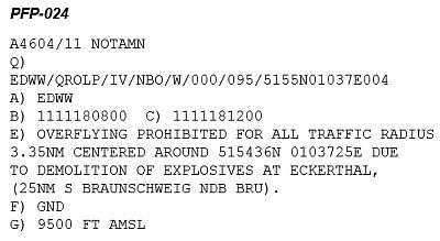
Up to which altitude is an overflight prohibited according to the NOTAM? See figure (PFP-024)
Show solution
The correct answer is 'Altitude 9500 ft MSL' because the NOTAM specifies the altitude in feet above mean sea level (MSL). The other options are incorrect as they refer to meters, flight level, or height above ground, which do not apply here.
The EOBT (estimated off-block time) is specified in the ATS flight plan as...
Show solution
The EOBT in the ATS flight plan is always given in Coordinated Universal Time (UTC) to ensure a worldwide standard. Central European Time, Local Mean Time, and Standard Time are not globally consistent and thus not suitable.
What must be considered for cross-border flights?
Show solution
For cross-border flights, filing a flight plan is required so authorities are informed. The other options are not generally mandatory or relate to different situations.
What happens to the true airspeed at a constant indicated airspeed during a climb?
Show solution
True airspeed increases during a climb at constant indicated airspeed because air density decreases with altitude. The other answers are incorrect: TAS does not decrease or remain constant; it rises as you climb higher.
Given the following data: Take-Off fuel = 200 lbs Alternate fuel = 40 lbs Final reserve fuel = 30 lbs After 25 minutes the remaining fuel is 120 lbs. Assuming that fuel flow will remain unchanged, the remaining time to the destination should not exceed:
Show solution
15.6 min is correct because only the fuel above alternate and reserve (120-40-30=50 lbs) can be used to reach the destination. With a fuel flow of 2 lbs/min (80 lbs in 25 min), 50 lbs last 25 min. But only the time to the destination counts, so 15.6 min is correct. The other options are too high.
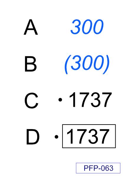
(For this question, please use annex PFP-063) According ICAO, what symbol indicates a general spot elevation?
Show solution
The correct symbol for a general spot elevation according to ICAO is symbol C. This symbol shows a small number with a dot below it. The other symbols represent different map features and not spot elevations.
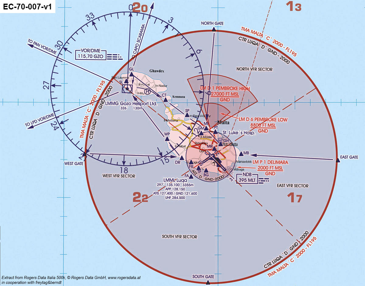
(See attachment EC-70-007-v1) You are approaching LMML (Luqa) and would like to monitor the ATIS. What is the corresponding ATIS frequency?
Show solution
The correct ATIS frequency for LMML (Luqa) is 127.400 MHz. This frequency is officially assigned for the airport's automatic weather and information service. The other frequencies are used for different services or airports and are not correct here.
(See attachment EC-70-007-v1) You plan a midfield crossing in LMML (Luqa) from west to east at altitude 6500 ft. What is the frequency you must use to request for permission?
Show solution
128.150 MHz is the Luqa Tower frequency, responsible for midfield crossings at 6500 ft. The other frequencies are for different services: 135.100 MHz is Approach, 121.600 MHz is Ground, and 127.400 MHz is Delivery. For this altitude, you must contact the Tower.
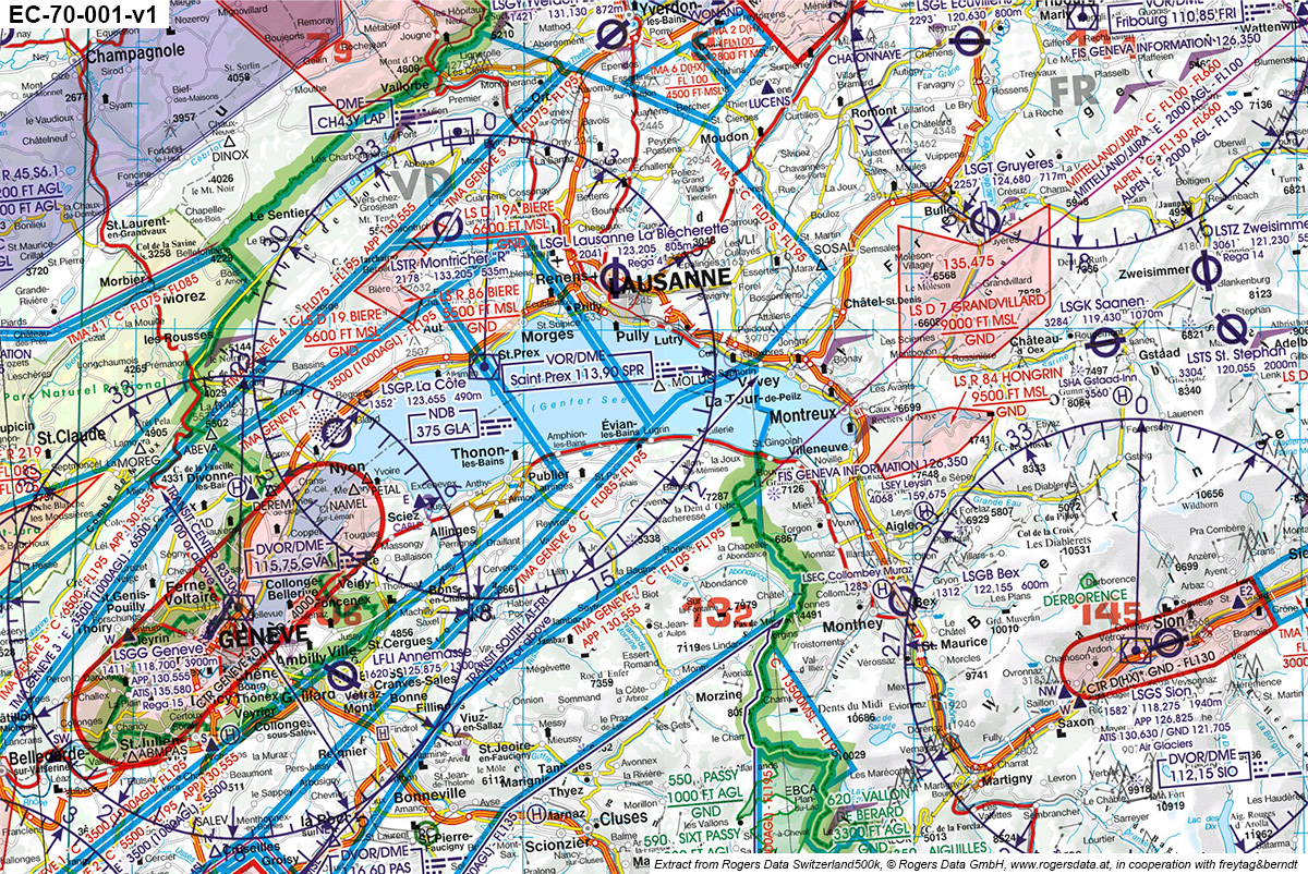
(See attachment EC-70-001-v1) What is the frequency of VOR/DME SPR south-west of Lausanne?
Show solution
The correct frequency for VOR/DME SPR southwest of Lausanne is 113.90 MHz. This is shown on the aviation chart. The other frequencies are for different navigation aids or not suitable for VOR/DME (e.g., 375 MHz is not a VOR frequency).
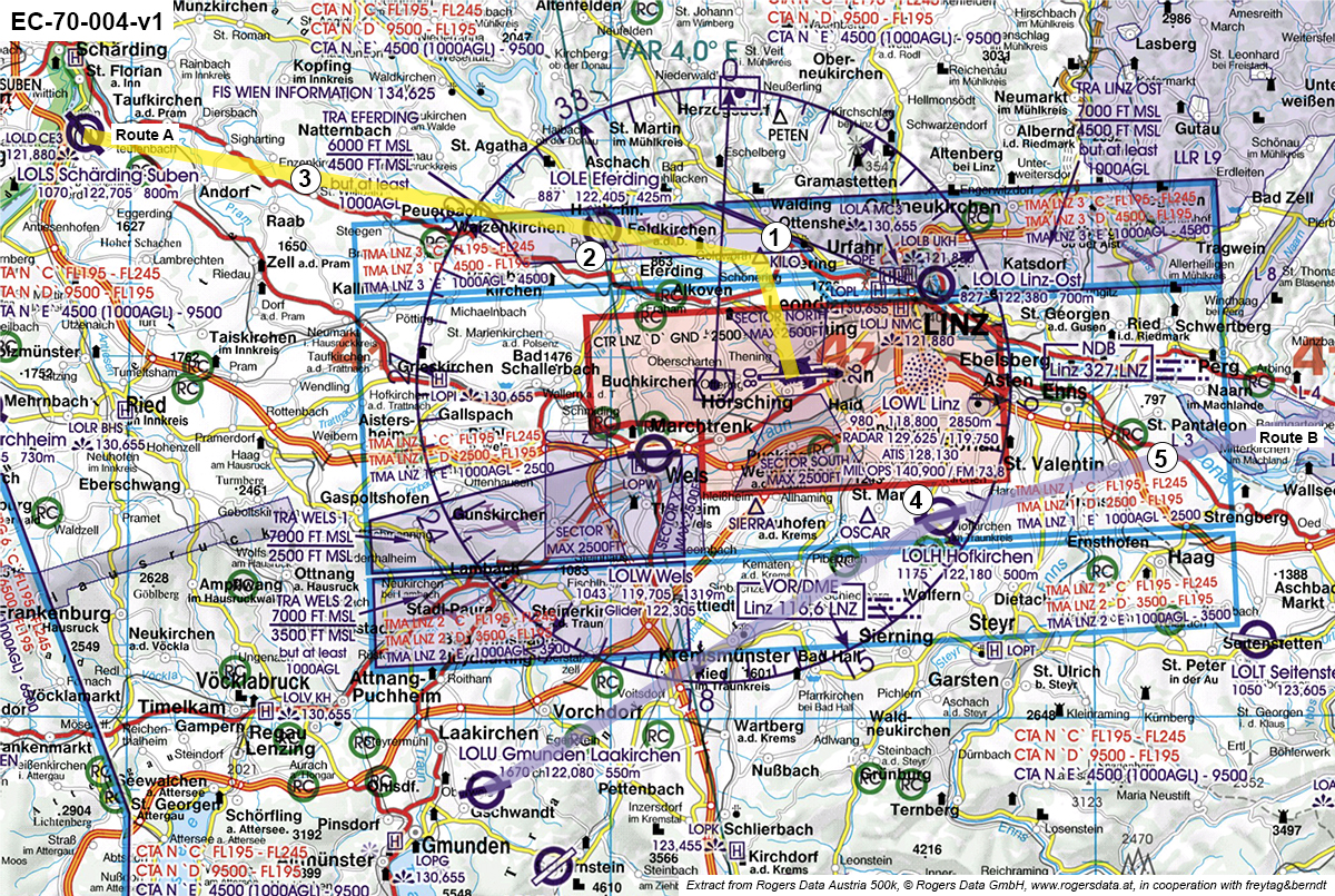
(See attachment EC-70-004-v1) After take-off from LOWL (Linz) on Route 1 (yellow), you head directly for KILO (point 1). How can you verify reaching KILO by using radio aids? Remark: Radials and bearings are approximate.
Show solution
The correct answer is tuning LNZ VOR/DME (116.60 MHz) to radial 018 and monitoring the DME, as KILO is located on this radial. The other options use incorrect radials or NDB/bearings, which do not help to identify KILO's position.
(See attachment EC-70-004-v1) You are flying on route A (yellow) at altitude 6500 ft. What airspace are you in at point 2?
Show solution
The correct answer is 'TMA LNZ 3 "D"' because point 2 is located in this area on the chart and 6500 ft is within the vertical limits of TMA LNZ 3 class D. The other options are incorrect as they refer to the wrong TMA or airspace class.
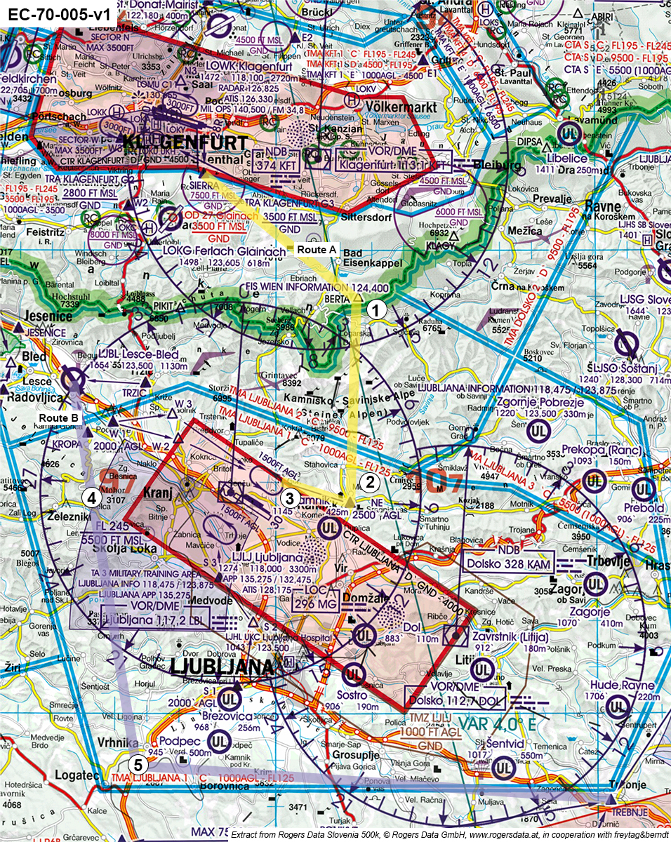
(See attachment EC-70-005-v1) What is the approximate radial of DOL VOR/DME, which indicates the turn overhead point 5 on route B (purple)? Remark: Radials and bearings are approximate.
Show solution
The correct answer is 245. The 245 radial from DOL VOR/DME matches the turn overhead point 5 on route B (purple). The other radials (195, 095, 375) point in different directions and do not correspond to the turn's location.
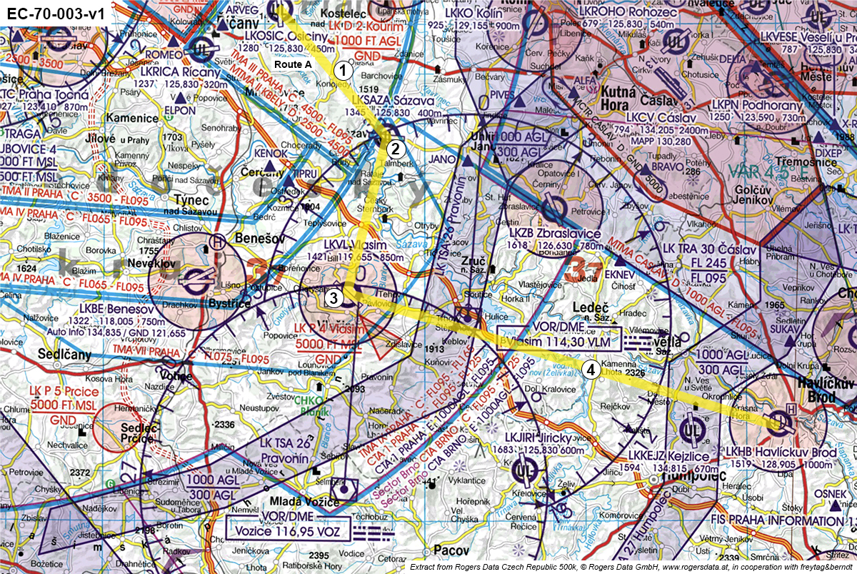
(See attachment EC-70-003-v1) Proceeding on route A, how can you verify reaching turning point 2 by using radio aids? Remark: Radials and bearings are approximate.
Show solution
Correct: Tune VLM VOR/DME (114.30 MHz) radial 330 with the correct DME, as point 2 is on this radial and distance. Others are wrong because they use the wrong VOR or radial, so they do not identify point 2 correctly.
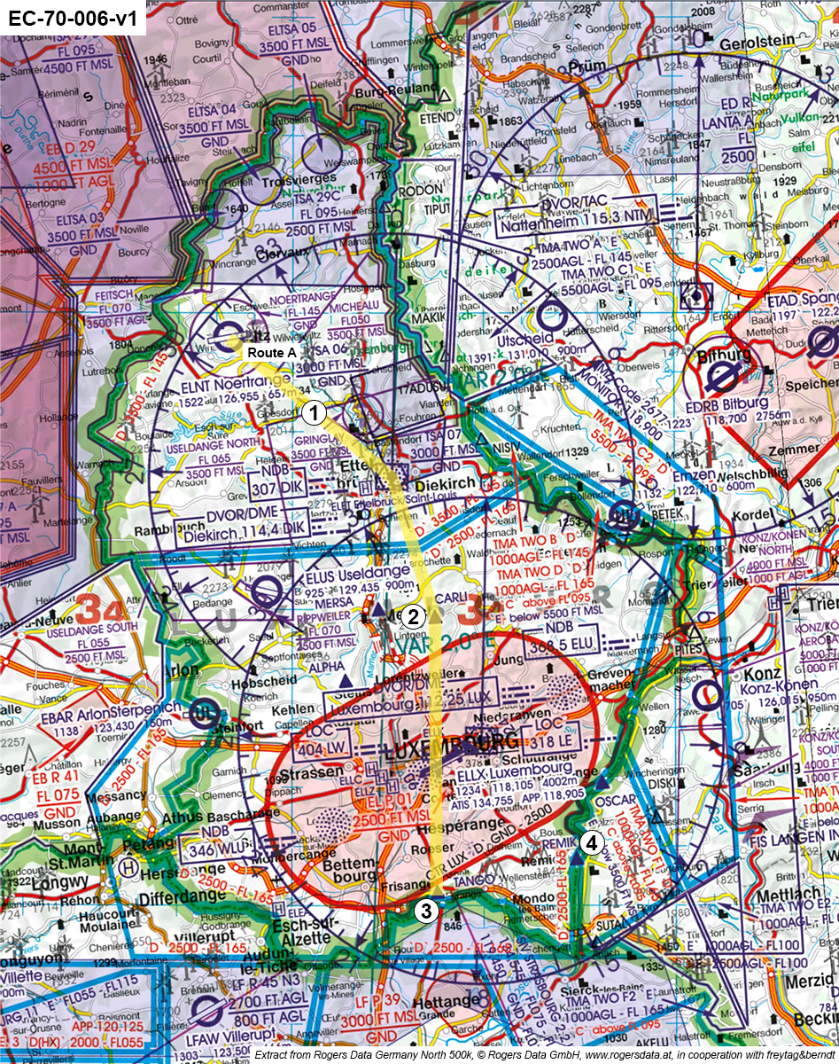
(See attachment EC-70-006-v1) After take-off from ELNT (Noertrange) on route A, you reach altitude 4500 ft at point 1. What airspace are you in at this position?
Show solution
The correct answer is airspace D, because at point 1 at 4500 ft, the chart shows entry into controlled airspace D. Airspace C is higher, E and G do not apply here as they are below or outside the control zone.
The thickness of the wing is defined as the distance between the lower and the upper side of the wing at the...
Show solution
The thickness of the wing is defined as the distance between the lower and upper side at the thickest part of the wing. Only here is the maximum thickness measured. The other options are incorrect because they refer to thinner, inner, or outer parts, not the maximum thickness.
What is a tubular steel construction with a non self-supporting skin referred to as?
Show solution
A tubular steel construction with a non self-supporting skin is called grid construction, as the tubes carry the loads and the skin is only a cover. The other types refer to structures where the skin is load-bearing.
Primary fuselage structures of wood or metal planes are usually made up by what components?
Show solution
Fuselage structures are mainly made of frames and stringers. Frames give shape and strength across, stringers run lengthwise. Girders, ribs, and covers are not the main fuselage elements; ribs are for wings, covers are not structural.
A construction made of frames and stringer with a supporting skin is called...
Show solution
Semi-monocoque construction uses frames and stringers with a load-bearing skin. Grid construction lacks a supporting skin, wood- or mixed construction refers only to materials, and honeycomb structure is a special lightweight design, not the described type.
What are the major components of an aircraft's tail?
Show solution
The correct components of the tail are the horizontal tail and vertical tail, as they provide stability and control around the pitch and yaw axes. Steering wheel, pedals, ailerons, and rudder are either control devices or belong to the wings, not the tail.
The sandwich structure consists of two...
Show solution
Correct: two thin load-bearing layers and a light core material. This gives high strength with low weight. The other options are wrong because they mention thick layers or a heavy core, which would make the structure unnecessarily heavy.
Which constructional elements give the wing its profile shape?
Show solution
Ribs give the wing its profile shape because they define the cross-sectional form. The spar mainly carries bending loads, planking provides a smooth surface, and the tip only shapes the end of the wing.